Monument Valley – Kayenta – Cameron – Grand Canyon NP – Williams
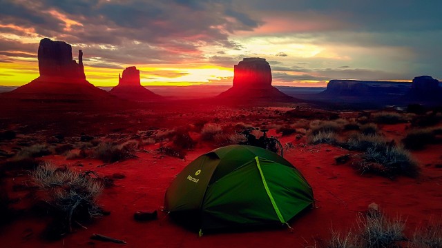
It was freezing, when I watched the sun rise behind the monumental pillars. Monument Valley was a place, I had somewhat randomly chosen to be my highlight – and it was, among many others, exactly that.
Es war eiskalt, als ich die Sonne hinter den monumentalen Felsen aufgehen sah. Monument Valley war der Ort, den ich mir ich relativ willkürlich als Highlight ausgewählt hatte – und das war es auch, nebst anderen.
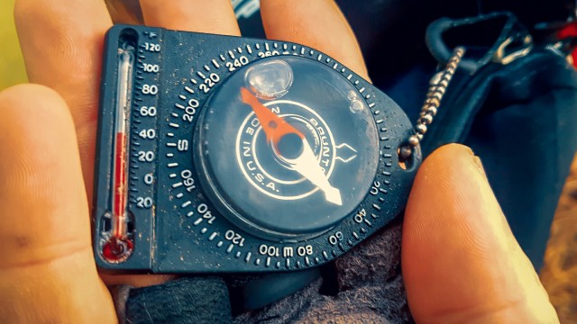
The only place I could get the stove to work and boil some water for coffee was underneath a wind shielding flight of stairs. The wind blew strong and cold, however, did not bring the fore-casted snow and sleet – yet.
Die einzige Stelle, wo ich den Kocher ans Brennen bekam, um Kaffeewasser zu kochen war unter einer kleinen Treppe. Es wehte kalt und kräftig, brachte aber nicht, wie vorhergesagt, Schnee und Regen – noch nicht.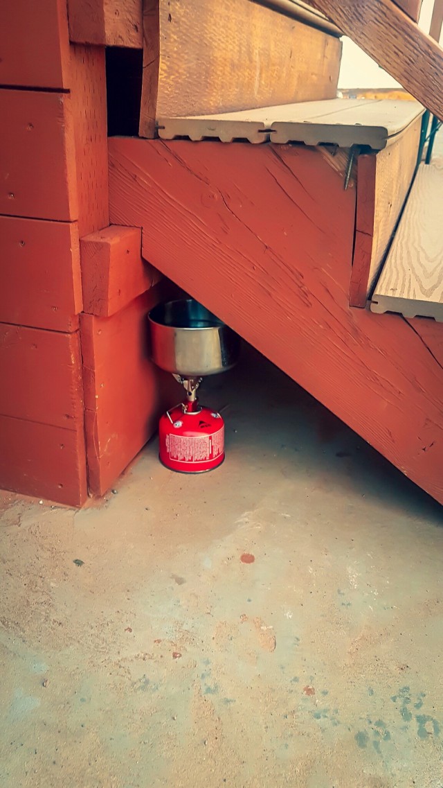
It went downhill to the Arizona border line. Kayenta was 40km away and the ride rather boring, except for when an RV nearly hit me. It overtook so closely that it slightly touched my rear view mirror. My knee-jerk reaction was a curse and the middle finger.
Bis zur Arizona Staatsgrenze ging es bergab. Kayenta war 40km entfernt und die Fahrt dahin eher langweilig, mit Ausnahme des Wohnmobils, das mich nur fast erwischte. Es überholte so knapp, dass es meinen Rückspiegel leicht berührte. Von hier waren profane 40km bis Kayenta, mit Ausnahme des Wohnmobils, das so nah an mir vorbei rauschte, dass es meinen Rückspiegel berührte. Mein Reflex war ein Fluch und der Mittelfinger.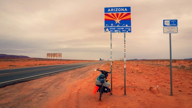
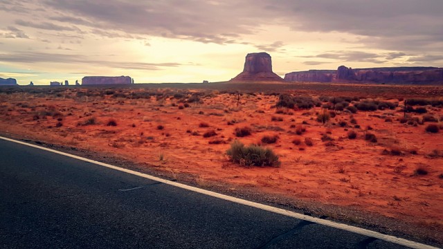
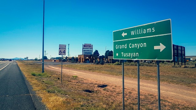
A fortiori, I wanted to get off the Hopi Reservation by hitching a ride. It was thumbs-up for an hour until a woman from Flagstaff gave me a lift. During this chatty, two hour ride, the expected rain and snow came. Cameron, a tiny town at the turn-off to the Grand Canyon was still on native territory, which ended “only” 40km up the road.
Umso mehr wollte ich nun per Anhalter von dem Reservat runter. Eine Stunde Daumen hoch bis eine Frau aus Flagstaff mich mitnahm. Während unserer zweistündigen, gesprächigen Autofahrt kam der erwartete Schneeregen. Cameron, eine kleine Ortschaft an der Abbiegung zum Grand Canyon ist noch Teil des Reservats, welches nach 40km die Straße hoch endete.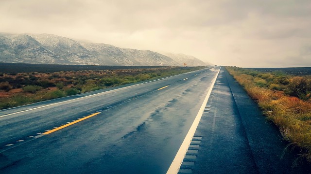
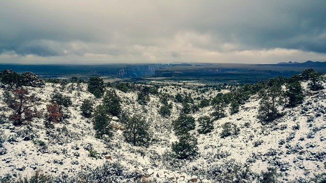
The weather didn’t feel too bad down here, despite my non-waterproof shoes and gloves. But what began as a motivated ride uphill soon turned into a painful experience that became wetter, colder and overall worse as I progressed further and higher. My hands and feet were very cold. At the end of the day, I didn’t make it off the reservation, but sought shelter in one of those wooden sheds by the side of the road, the locals use to sell their handcrafted jewelery.
Das Wetter fühlte sich hier unten nicht so schlimm an, trotz meiner nicht wasserdichten Schuhe und Handschuhe. Aber was als motivierter Ritt bergauf begann, mutierte bald zu einer schmerzhaften Erfahrung, die immer kälter, nasser und allgemein schlechter wurde, je höher und weiter ich kam. Meine Hände und Füße waren krass kalt. Am Ende schaffte ich es nicht bis zur Reservatsgrenze, sondern suchte Schutz in einem der hölzernen Verschläge, die die Einheimischen zum Verkauf ihres Schmucks nutzen.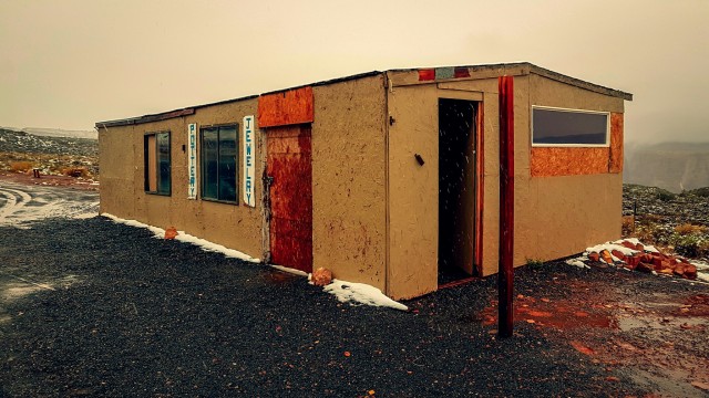
I did this with the kind permission of Austin, a local ranger, who must have felt pity for me. My luck, because otherwise, I would have been rather uncomfortable with what could be best described as breaking and entering. But this way, I climbed in through a window, opened the door from the inside and pushed the bike inside with a clear conscience. The roof was leaking in a number of places and it was as cold and damp inside as it was outside. However, I did not complain; there were enough dry spots and shelfs to cook and sleep on.
Ich tat dies mit der freundlichen Erlaubnis von Austin, einem Reservatsranger, der wohl Mitleid mit mir hatte. Mein Glück, denn sonst wäre mir bei dem was man sonst einen Einbruch nennen müsste, nicht wohl gewesen. Aber so kletterte ich mit reinem Gewissen durchs Fenster, öffnete die Tür und schob mein Rad hinein. Wasser tropfte an mehreren Stellen durchs Dach und innen war so kalt und nass, wie draußen. Ich beschwerte mich nicht; es gab genügend trockene Stellen und Auslagen auf denen ich kochen und schlafen konnte.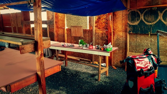
Poorly-rested, I woke up the next morning after a cold night in a damp sleeping bag. The weather seemed to have improved a little though and it was dry when I left the shed, again through the window. Half an hour later, the rain was back and quickly seeped through my inadequate layers of insulation, making especially my hands and feet go more and more numb by the minute. Eventually, I directed the warm air of every breath into my clenched fists, alternating hands with every exhale and pedal stroke – that helped, but my feet were two dead stumps of ice, pushing down the pedals.
Gut unausgeruht erwachte ich nach einer kalten Nacht in meinem klammen Schlafsack. Das Wetter schien sich gebessert zu haben und es war immerhin trocken als ich die Hütte, wieder aus dem Fenster kletternd, verließ. Eine halbe Stunde später war der Regen zurück und sickerte schnell durch meine unzureichenden Schichten Isolation, Hände und Füße von Minute zu Minute tauber werden lassend. Irgendwann begann ich, meine Atemluft in die geballten Fäuste zu leiten, mit jedem Atemzug und Pedaltritt die Hand wechselnd – es half, aber meine Füße waren lediglich zwei Eisklumpen, die die Pedale runterdrückten.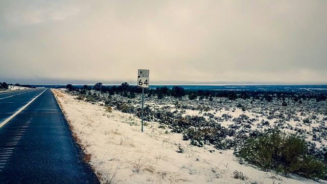
The road went continuously uphill and after two slow, painful hours, I realized I had made another mistake: Not only had I underestimated the weather and overestimated the performance of my gear, I also had overlooked that Komoot, the navigation-app, had planned to send me to the Grand Canyon Village via single-track. With everything covered in snow, I had missed the turnoff, of course and given the weight of my bike and the snow, it wasn’t a good idea to take the trail anyway. As I looked in disbelief at the screen, my motivation dropped – now matching the temperature – below zero. Via single-track it would have been less than 20 km – now it was more than double.
Die Straße führte kontinuierlich bergauf und nach zwei schmerzvollen Stunden, merkte ich, dass ich einen weiteren Fehler gemacht hatte. Nicht nur hatte ich das Wetter unter- und die Leistung meiner Ausrüstung überschätzt, ich hatte auch übersehen, dass Komoot, die Navi-App, mich über einen Wanderpfad zum Canyon schicken wollte. Die Abzweigung hatte ich bei dem Schnee natürlich nicht gesehen und außerdem wäre es auch eine schlechte Idee gewesen, den verschneiten, steinigen Pfad mit dem schweren Rad zu nehmen. Als ich ungläubig auf den Bildschirm sah, sank meine Motivation – passend zu den Temperaturen – unter Null. Über den Pfad wären es knapp 20km bis zum Grand Canyon Dorf – über die Straße allerdings noch mehr als doppelt so viel.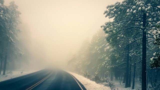
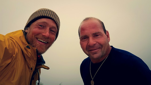
I was thinking about going back, about rolling down all the way to the shed, wrap myself up warm in the sleeping bag until I regained feeling in my extremities and postpone the ascend until the next day. Just then, a big truck stopped. The driver thought it was very cool what I did (At the time, I could not agree at all) and eventually offered a lift uphill, which in turn I thought was really cool. I accepted and climbed into the truck, immediately aiming my hands and feet at the heating.
Ich dachte schon daran, umzukehren, den Berg zur Hütte zurückzurollen, mich in meinen Schlafsack einzumummeln bis Leben in meine Extremitäten zurückkehren würde und den Aufstieg auf den nächsten Tag zu verschieben. Doch dann hielt ein großer Pick-up. Der Fahrer fand was ich machte richtig cool – ich konnte ihm gerade nicht beipflichten – und bot mir an mich zum Canyon zu bringen, was ich wiederum sehr cool fand. Ich nahm an, kletterte in den Truck und presste Hände und Füße sofort an die Heizung.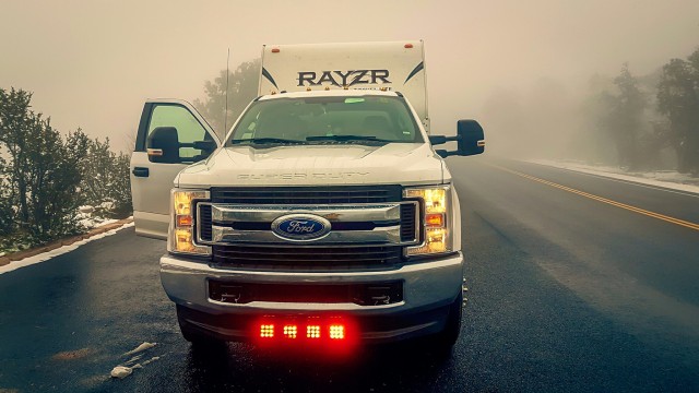
JC and I had a fun chat on our way to the Grand Canyon, of which we saw almost nothing since it was tucked away in fog, mist and clouds. I was relieved not to be on this road; visibility was practically zero. We arrived at the village, ate some hot soup on the parking lot and eventually went our ways. Grateful for the lift, the nice encounter and the new won sensation in my feet, I took my bike and went to check in the hiker/biker campground. “How much for a night?”, I asked the ranger behind the window. “Our new system isn’t working fully yet, so for cyclists it’s free.”. “Free?! Great! I’ll stay two then.” I couldn’t wait to get out of my sweaty clothes, which had kept me cold and shivering since I climbed into JC’s truck
JC und ich quatschen viel miteinander auf unserem Weg zum Grand Canyon, den wir kaum zu Gesicht bekamen, da er fast vollständig in Wolken, Dunst und Nebel hing. Ich war froh nicht auf der Straße zu sein. Die Sicht war quasi gleich null. Wir kamen im Dorf an, aßen eine heiße Suppe und gingen dann unsere Wege. Dankbar für die Fahrt, die nette Begegnung und das wiederkehrende Gefühl in meinen Füßen, fuhr ich zum Zeltplatz, um auf einer Hiker/Biker Site einzuchecken. “Wie viel für eine Nacht?”, fragte ich den Ranger hinter dem Glas. “Unser neues System funktioniert noch nicht ganz, für Radler also kostenlos.” “Kostenlos? Top! Ich bleib zwei.” Ich konnte es kaum erwarten aus meinen verschwitzten Klamotten raus zukommen, die mich frieren und zittern ließen seit ich in Jcs Truck gestiegen bin.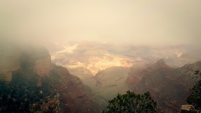
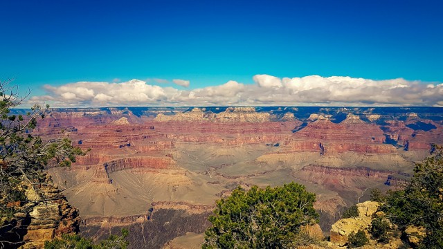
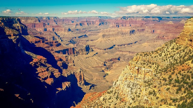
 The next day, the sky cleared up fully and I spend it hiking along the rim. The sun felt good and the views were pretty spectacular.
Am nächsten Tag war der Himmel wieder blau und ich verbrachte ihn mit einer kleinen Wanderung am Canyon entlang. Die Sonne tat gut und die Aussicht war ziemlich spektakulär.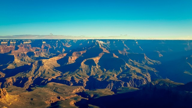
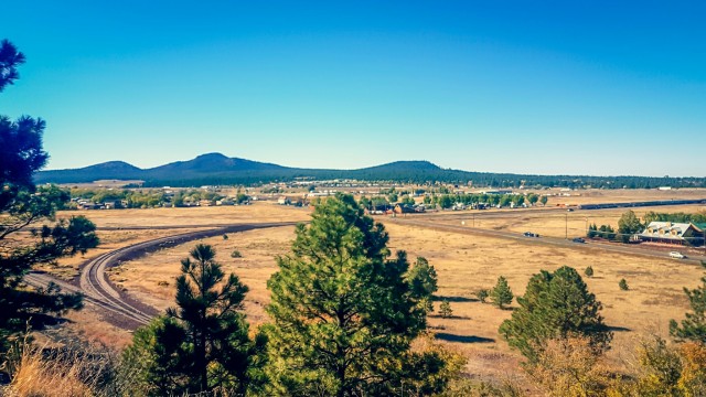
Two nights later, on a cold, sunny morning, strong tailwinds pushed me southwards on the 64. My day’s destination was Williams, an old, all-American town on (the historic) Route 66.
Zwei Nächte später, an einem kalten, sonnigen Morgen,schob mich starker Rückenwind auf der 64 gen Süden. Mein Tagesziel war Williams, ein alter, typisch amerikanischer Ort an der (historischen) Route 66.